|
Šibenik (approximately 56.000 inhabitants) is a big
and one of the oldest and best protected ports on the
Croatian side of the Adriatic Sea (43° 44' N, 15° 53'
E). It is situated in the sunken mouth of river Krka,
which in its length of 75 km and its pothole altitude
of 360 m forms a unique nature reserve.
The port is naturally sheltered from waves and winds.
It can be reached through the Sv. Ante Strait (2.700
m long and 120-300 m wide), which enables unobstructed
navigation of ships up to 50.000 DWT. The port is 10
m long, 300-1200 m wide and 8-40 m deep.
Weather conditions: northeastern and south winds blow
with gale force. Northeastern wind is strongest in
the northwestern part of the port and weakest on the
stretch of coast from the cathedral to the pier Gat
Krk. South wind causes high and short waves.
Sea currents: in the area south west of the entrance
to the Sv. Ante Strait an outgoing current of the speed
of 0,5 knots prevails when river Krka has a low inflow
and up to 3 knots when river Krka has a high inflow.
In the area southwest from the entrance into the Sv.
Ante Strait the currents are weak and have the speed
of 0,4 knots. When a south gale blows the speed of
NW current along the northeastern coast is 0,5 knots.
Sea level: average amplitudes of tides range from
0,2 - 0,4 m. Gales that blow during long periods of
time and abundant precipitation can raise the sea level
up to 1,0 m (cyclonic south wind) and lower it to 0,4
m (anticyclonic north eastern wind).
Density of water: on the surface layer (1-3 m of depth)
density ranges from 1.010,0 kg/m3 (during a high inflow
from river Krka) to 1.025,0 kg/m3 (during a dry spell).
In water deeper than 1-3 m density ranges from 1.023,0
- 1.028,0 kg/m3.
Anchorage: anchoring
is possible in case of emergency with the permission
from the Harbour Authority. It is best to anchor WSW
and SSW from the cathedral.
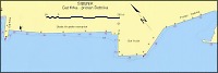
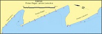
| Pier of Šibenik port (plan
of the location): |
• on the north eastern coast of cove Vurnaža is the
operative coast
of 312m of length and 5-8 m of depth
(company Luka drvo).
• on the northern part of cove Klobučac is the operative
coast
Rogač, which is 420 m
long and 8-10 m deep (company Luka Šibenik).
• on the north coast of cove Dobrika is pier Vrulje
(in the shape of trapezium), with operative coast which
is 113 m long and 7,2 m deep along the main part of
the pier and with the operative coast which is 132
m long and 9 m deep along the south eastern side of
the pier and with the operative coast that is 101 m
long and 7 m deep along the north western side of the
pier (company Luka Šibenik).
• from pier Vrulje to he bottom of cove Dobrika operative
coast is 240 m long and 10 m deep (company Luka Šibenik).
|